THE LANDSCAPE OF LANCASHIRE
The landscape and therefore scenery of the Lancashire region is determined by the following in order of importance
- The underlying rock geology
- The superficial (ie that which rests upon the bedrock) geology largely as a result of the last Ice Age
- On going physical processes in the landscape such as rivers and seas
- Human influence and particularly the development of urban areas and transport links
I will concentrate upon the first two, as the other two are more familiar and understandable.
The Geology of Lancashire
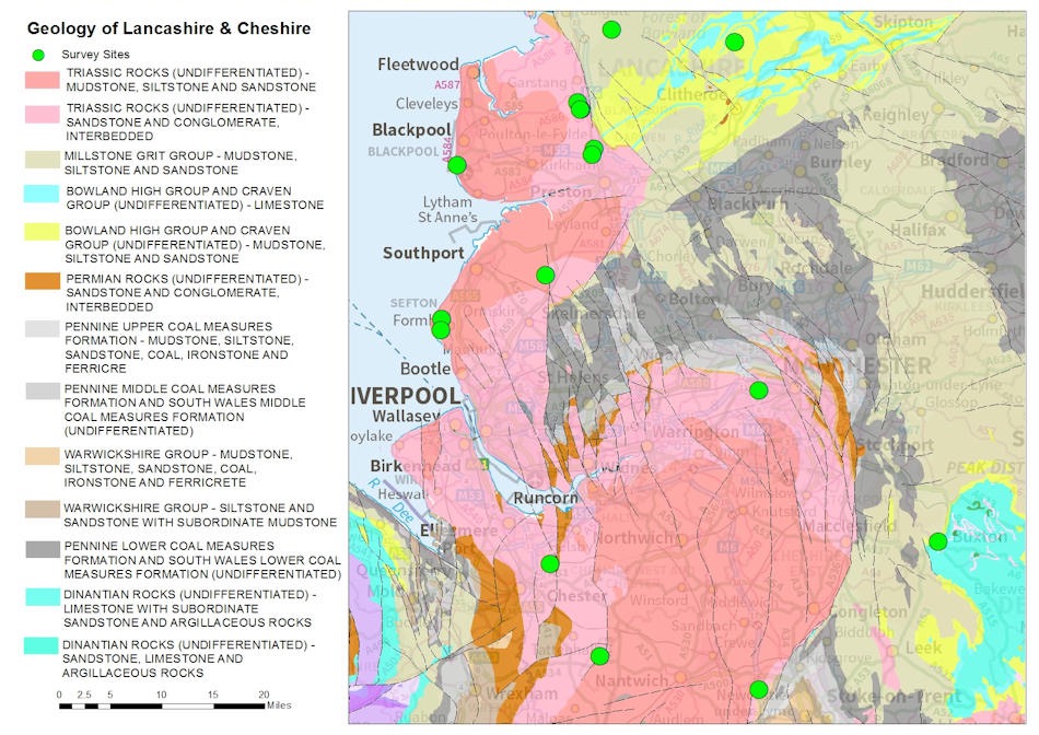
The bedrock geology of Lancashire is dominated by two eras of geological time.
The Carboniferous, which dates from approximately 360 million to 300 million years ago and the younger rocks of the Triassic period, which date from 251 million to 210 million years ago. The intervening period is called the Permian period but there are few rocks of this area that are represented in Lancashire although extensive deposits occur in Cheshire and a small out layer in the far north of Lancashire near Morecambe. The explanation for this gap in the geological time record will be explained later.
Geological Principles.
To fully understand the geology and therefore the landscape of the county we must understand certain principles.
Firstly, all of the rocks in the county are sedimentary rocks i.e. rocks formed by the accumulation of material derived from the erosion of pre-existing rocks and/or organic materials and/or chemical processes. With time and the process of digenesis, the unconsolidated material, eg sand in a riverbank, becomes a coherent hard sedimentary rock. They are classified based upon the character of the material or sediment that predominates in the rock although in most rocks there is a spectrum of materials. There are broadly three types of materials
- clasts or remains of previous rocks and these are sub classified based upon the size of the grains. Thus the finest are mudstones or shales, grading up to sandstones and then into conglomerates, which incorporate pebble sized clasts.
- Limestones are made from the accumulation of calcareous organisms such as corals whilst coals are made from the remains of vegetation
- Although not very common these include salts made from the process of evaporation and certain ores such as iron ore
Secondly, the most important aspect of sedimentary rocks is that they largely reflect the environment in which they were created. Thus limestones are created in shallow warm seas, which allow organisms to grow and secrete calcium, coals and oils are produced in forest and swamp type environments that allow vegetation to grow, die and accumulate, mudstones in deeper seas and sandstones in river and delta systems.
Thirdly an important principle of geology is the age of rocks, not just in absolute terms, but also relative to each other. In simple terms if a sediment lies on top of another then it must be younger as the rock below must have existed before for it to be deposited upon it. Thus if you climb a hill generally you will be climbing up the geological time sequence reaching younger and younger rocks as you climb and alternatively if you descend into a valley you will descend into older and older rocks and we can see excellent examples of this during our walk.
Fourthly, generally sedimentary rocks are laid down in flat bands over an area. However, with distance the type of sediment being deposited at the same time will vary laterally as the environment changes. Thus over miles a sandstone deposited by a river or delta can become less and less thick and eventually become a mudstones as we go further out into the sea and the influence of the river comes less.
Finally, whilst the sediments are originally laid down in horizontal flat layers, which can often be seen in quarry and rock faces. However, rocks can subsequently be subject to forces by the movement of tectonic plates and put under significant pressure. During these periods, the rocks can become folded so the layer of sediment is no longer flat. Folds can be a few meters across or can be many miles in length and we can see the impact of folding during our walk. Alternatively rather than gradually bend with forces the rocks can literally break in the form of a fault in which the rocks move on either side of the break move relative to each other. The most common type of fault is the normal fault when rocks on one side of the fault fall relative to the other. This can result in a boundary where you cross from rocks of one age to another at the same height. Normal faults can be as a result of decompression as well as compression. Rocks can also move laterally relative to each other and in faults with shallow angles lower older rocks can be pushed above younger older rocks. These are know as thrust faults and are common in mountain building environments, when the earths crust is being compressed and shortened as two tectonic plates converge upon each other. You may think that Lancashire is many miles away from the edge of any tectonic plate but the geological record clearly shows that this was not always the case.
The Geology
Armed with this small amount of geological knowledge, I shall try and explain in overview the geology of Lancashire, which we can then observe and see how it impacts the landscape and scenery on our walk.
The oldest rocks in Lancashire are from the Carboniferous period. Traditionally this was divided into the Lower, Middle and Upper with the Lower characterised by extensive limestones, the Middle by coarse sandstones or “grits” and the Upper by coal measures. With the need to correlate many rocks of equivalent ages across the world the nomenclature has become much more complicated, with new names, new boundaries and new subdivisions. If you find the geological time chart published by the British Geological Survey you will see that the Lower Carboniferous is now known as the Dinantian ( split into the Tournasion and Visean), the Middle as the Namurian and the Upper as the Westphalian. The Stephanain is not represented in our geological sequence much like the Permian period, which follows.
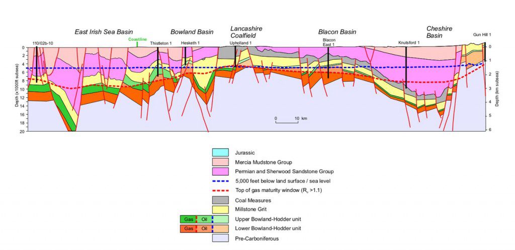
There are only a few rocks which date from the Lower Carboniferous (Dinantian) in Lancashire, in contrast to the extensive thick limestones which populate the Yorkshire Dales to the North East. The famous Craven fault , which runs from the NW to SE and features Malham Cove, separates the two regions. This was probably an active fault at the time and separated a shallow basin which accumulated thick limestone deposits to the NE from a deeper basin in which calcareous mudstone were deposited. There are a few limestones typical of the Lower Carboniferous in Lancashire and these can be found in the bottom of the Ribble Valley, and provide the raw materials for the cement factory at Clitheroe. However, these tend to be thin in nature and separated by black mudstones. A great example of these can be found in the A59 Clitheroe By-pass road cutting near Chatburn just north of Clitheroe. Above these limestones are extensive thick deposits of shales know as the Worston and Bowland Shales and these are the rocks which potentially hold huge reservoirs of gas and are the subject of the controversial discussions regarding fracking.
In the following Namurian period, great river delta systems advanced southwards depositing the typical thick coarse sandstones known as the Millstone Grits. These rocks are found throughout the county and typically form the moorlands of the region including the Bowland Fells and the West Pennines. In addition there are smaller outliers of this rock , which form many of the small ridges or escrapments running in a NE-SW direction,in the area including those at Billinge, Wilpshire, Mellor and the Longridge Fells . Pendle Hill itself gives its name to the oldest and thickest sansdtone from this period – The Pendle Grit Formation. This reaches thicknesses of 550m SW of Settle and 360m on Pendle Hill itself. In between the many sandstones of this era are mudstones, which represent periods when the seas transgressed over the area. Marine fossils remaining from these periods allow correlation of the various sandstones across the region.
Above the Millstone Grits are the Coal Measures of the Upper Carboniferous. These were laid down in a single depositional basin covering most of northern England. The basin subsided at different rates gives rise to very different thicknesses of rocks deposited with a maximum thickness of 1900m around Manchester. The Coal Measures represent an environment of rivers, shallow lakes and bays and lagoons with extensive vegetation growing probably not dissimilar to the Everglades in Florida, and which were subject to occasional marine flooding. The resultant rocks grade from mudstones to siltstones deposited in the bays and lagoons and sandstones deposited by river channels flowing through this environment. Within this are subordinate amounts of coals and ironstones created from the compaction of the remains of vegetation that flourished in the equatorial climate of the time. There are many fossils found in these rocks from bivalves (mussel like creatures) and ostracods (crustaceans) to fish and tree ferns and horsetails. The latter were commonly found by miners, including roots in situ, leaf fronds, plant stems and broken tree trunks and branches. The identification of similar species of fossils allows correlation of coal beds and sandstones, which vary greatly in character across the whole of the North.
At the end of the Carboniferours period was the Variscan Orogeny – a period of significant earth movements, during which our Carboniferous rocks were deformed in to gentle folds and there was extensive faulting around the previous basin faults. This was followed by uplift and erosion such that the Coal Measures were only preserved in areas of down warping or down faulting. Thus the current variable distribution of the coalfields across the region is not an original feature but a product of this deformation and faulting of what would once have been a continuous series of rocks across the whole region.
We will see a great cross section of the Carboniferous geology of the area when we walk from Pendle Hill down to Downham and across the Ribble valley to Grindleton. During this part of the Way we start in the Coal Measures to the East of Pendle Hill and then the Pendle Grits before descending down the geological time sequence into the valley bottom where the Lower Carboniferous limestones can be found including the remnants of Reefs (Worsaw Hill near Downham), which are a form of limestone created close to the shore. Each change in the rock type creates another clear band in the hillside depending upon its resistance to erosion.
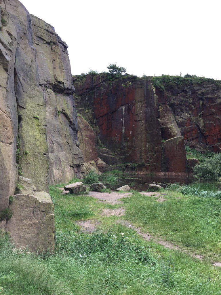
Over Lancashire few rocks of Permian origin remain as the area continued to be eroded in a largely a hot and desert type environment. However, not far to the south, in Cheshire, a seaway opened, which extended far into Eastern Europe, and is typified by extensive deposition of salt deposits. A desert environment re-established itself in the Triassic period, in which river and wind sedimentation took place characterized by the red colour of the rocks. These rocks are extensively featured in the west of Lancashire and were largely deposited unconformably over the remains of the Carboniferous rocks.
After the Triassic period the area was completely flooded and submerged below what is known as Tethys Ocean in which the extensive marine deposits of the Jurassic and Cretaceous period were deposited. However, there are no deposits of this age represented in the County unlike Southern England and East Yorkshire, where there are extensive deposits. So it is difficult to piece together the events over this period of 170 millions years. It is thought that significant deposits from this era were deposited but these were all removed during the Palaeogene and early Neogene Eras – as part of the Alpine uplift in Europe.
The Superficial Geology of Lancashire.
The final Geological Period that has had an impact upon the scenery of Lancashire is the Quaternary Period, which began around 2 million years ago and was marked by climatic deterioration with oscillating periods of colder climates in which glaciers and other “Ice Age” features existed and shorter milder interglacial periods. In addition to the impact of ice must be added the erosional and depositional capacity of water associated with the ice whether in milder periods or during the summer periods.
During at least two stages ice covered most of the UK. However, the impact of much of these earlier glacial stages have been removed and Lancashire is dominated by the impact of the Late Devensian stage ie between 24,000 and 10,000 years before present (BP). During this period, ice advance from the North West down the Irish Sea but also from the NE via Ribblesdale. These two ice flows met in the Ribble valley and the predominance of each at different times can be seen by the origin of the stones/clasts within the deposits in the region. During the oldest glacial periods the sea level is thought to have been up to 100 m lower than at present exposing much of the sea floor. Whilst Ice covered much of the region, the Pennines were thought to be exposed and the ice filled the extensive low lying plain to the west and south. Glacial deposits of up to 90m thick occupy much of lowland Lancashire in a complex formation of intercalations of various sediments deposited by the glaciers from meltout and glacial rivers, sands and gravels to fine clays in glacial lake environments. These deposits where once know as boulder clay but this one term is too general for the variety of environments, and sediments which can be found across the region.
A common feature of glaciers are drumlins. These rounded mounds often several hundred meters in length consists of glacial deposits thought to have formed beneath the glaciers during periods of fast flowing ice. We will see examples on the Way but just south of Skipton and near Hellifield is an extensive area with many individual drumlins.
Besides the products of deposition, the impact of meltwater is also significant. There are many meltwater channels in the region. Perhaps the most impressive are the valleys now occupied by the Rivington Reservoirs. In addition there are tunnel valleys, when meltwaters flowing under glaciers under great hydrostatic pressure and loaded with ice and rock debris cut channels into the underlying bedrock. Subsequently these would be partly or totally filled with glacial sediments so that they are now only discoverable by seismic surveys of the bedrock below the recent superficial glacial deposits. The Rivers Dee, Mersey and Weaver are all controlled by such tunnels as is the Douglas Valley. Frequently these tunnels followed fault lines, which had been exploited by the pre glacial topography.
There are also numerous examples of the ice sheets causing drainage diversions. It is thought that the Ribble itself and certainly the River Hodder, originally flowed north of Longridge Fells until it was diverted on its current course. The River Darwen has cut a deep gorge into bed rock near Hoghton Towers as it’s previous course was filled with sediment. We will see this on the Way as part of the Northern Loop.
The Kirkham moraine is a huge feature, which forms most of the Fylde.
Finally it was once thought that many lakes, such as Accrington Lake where impounded as the ice began to melt and these gave rise to meltwater channels as the water tried to escape. At Cliviger east of Accrington is a gorge, where clearly water drain over the watershed east into the Calder valley.
At the very end of the Ice Age many of the mosslands or raised bogs of West Lancashire were created from vegetational deposits of nutrient rich lakes including Tareleton, Burscough, Croston, Mawdesley and Hoscar. Further inland are peatlands created in inland basins such as Red Moss at Horwich and Farrington and Hoole near Leyland.
Before I started this walk I had not truly understood the significant impact that the last Ice Age had upon the landscape of Lancashire. The above is only a selection of some of the features that are derived from the Ice Age. However, hopefully I can highlight some of the above on each Stage of the walk.


